Back to All Markets & Services
GIS – Geographic Information System Mapping
Turning Chaos into Clarity: GIS Mapping That Solves More Than Just Location
When infrastructure data is buried in spreadsheets, aging maps, or scattered records, it’s not just inconvenient, it’s risky. Missed connections, outdated asset locations, and incomplete system knowledge can delay projects, drive up costs, and compromise decision-making. That’s where we come in. Our GIS Mapping Services go beyond data collection —we help communities unlock smarter planning, improved utility management, and future-ready infrastructure strategies. From water main inventories and sewer system assessments to stormwater asset tracking and permitting support, we deliver custom GIS solutions that solve real-world challenges. We don’t just make maps—we make your systems visible, connected, and manageable. Because when you can see everything, you can solve anything.

Our Services
Wastewater
- Manhole Inspections
- Air Release Valve (ARV) Inspections
- Smoke Testing Defect Locations
- Sump Pump Inspections
- Backups/Overflows
- Storm Sewer Overflow (SSO)/Combined Sewer Overflow (CSO) Locations
- Lift Station Inspections
-
Environmental
- Outfall Inspection
- Rule 5 Permitting
-
Stormwater
- Manhole and Inlet Inspections
- Drainage Complaints
-
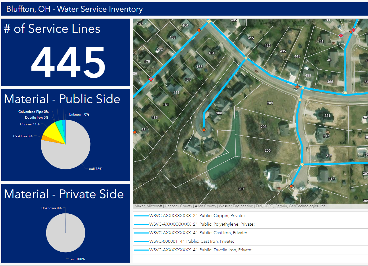
Custom Built Dashboards & Reports
Customized From Data Collection & Mapping:
- Inspections
- Water Main Leaks
- Drainage Complaints
- Overflows
- Public Logged Data
- New Installations
- Work Order Programs
- As-Built Records
- Wall Maps
Water Distribution
- Fire Hydrant Inspections
- Leak Hot Spot Locations
- Valve Inspections
- Lead Service Line Replacement Program
- Maintenance Logs/Programs
-